Travel Western North Carolina
Taking the Train: Bryson
Swain County
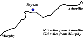
Altitude: 1,750 feet
Population: 612
"While Bryson is the name of the station, the town is known popularly as Bryson City. It is the county seat of Swain County and is one of the most important places in western North Carolina. A peculiarity of the town is that it is bisected by the Tuckasegee River. The principal industries are lumbering and wood-working establishments. The country surrounding the town is devoted largely to general farming and stock raising. From far and near hunters and fishermen come here for the fine sport to be enjoyed in the vicinity. While the scenery in the neighborhood is not particularly beautiful, Bryson affords a most convenient entrance to some delightful trails through the Smoky Mountains. Cold Spring Knob rises just to the North of the town and to the South are Cliff Mountain, Rattlesnake Cliff and Rich Mountain, all interesting and historic peaks. About twelve miles from Bryson, over a first-rate driveway, is Terry Bald and thence, by a trail, it is about four miles to the crest of Clingman’s Dome, which rises 6,660 feet into the clouds, almost rivaling in altitude Mt. Mitchell, the highest peak in eastern North America."
"Just outside of Bryson the Railway crosses a charming mountain stream called Deep Creek, a short distance beyond which is the little station of Governors Island, 62.5 miles from Asheville and 60.6 miles from Murphy. It is located at the junction of Goldbreak Creek and the Tuckasegee River. At this point the Railway swings sharply to the Southeast, again crossing the Tuckasegee River just before reaching the small way station of Ela, 62.1 miles from Asheville and 61 miles from Murphy. The next station is Whittier, N.C. "
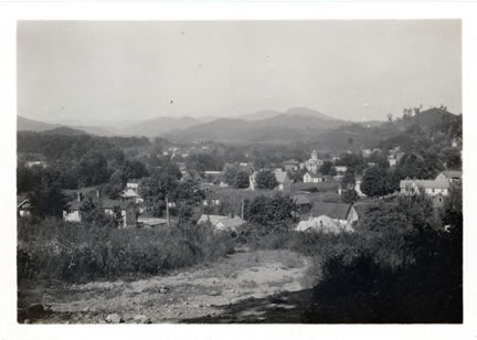
A view of Bryson City, c. 1920, taken by Horace Kephart. The Swain County Courthouse, which dates from 1908, is visible to the right of center, and is distinguished by its dome.
In addition to being a center for timber resources, the tour guide The Western North Carolina Section at a Glace (1912) noted the recreational potential of Bryson City and commented that, ”From far and near hunters and fishermen come here for the fine sport to be enjoyed in the vicinity.” Ernest L. Ewbank echoed this sentiment in his article “Fly-Fishing in North Carolina (Forest and Stream, January 6, 1916), and noted,
“. . . Beyond Waynesville there are streams all the way to Murphy; some far back in the forest, others quite near.
“Dr. Daniel Bryson of Bryson City, or his brother, Thad Bryson, would give intending anglers desired information at Bryson City, sixty-five miles west of Asheville.”
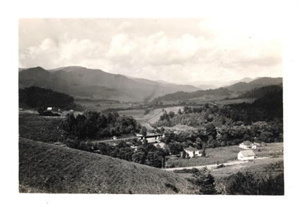
In this view near Bryson City, taken by Horace Kephart, c. 1920, the rail line and a road may be seen in the foreground and center. Even though the railroad provided greater passenger and freight transport than had been possible thirty years prior, residents of western North Carolina strived to improve connections to the region through improved roads. The 1916 tour guide Road Maps and Tour Book of Western North Carolina noted that, even though “Swain County offers many obstructions to road building, due to the many streams to cross and the steep topography of the country,” a twenty-two miles section of highway from Asheville to Murphy was under construction.
The North Carolina Corporation Commission’s report for 1912 stated that the Appalachian Railway Company operated a 6 ¼ mile long line from Ela, N.C. to Cherokee, N.C. The Jackson County Journal (Sylva, N.C.), in its April 16, 1909, issue, carried the announcement that the “Appalachian Ry. is Now Completed,” and declared that:
“The railway is of more than local importance because it passes through vast virgin forests up the Ocona Lufty river and affords wonderful views of mountain scenery, views hitherto unknown to the public because of the inaccessibility of the view points. Many people will be glad to travel over it simply for the scenery.”
Likewise, the Superintendent for the Cherokee Indian Reservation, headquartered at Cherokee, N.C., expressed optimism for the new railway in his 1910 annual report to the Bureau of Indian Affairs:
“The prices paid for farm and garden products are good, being much higher than those received up to three or four years ago, but market conditions are very poor. There should be considerable improvement in this regard in the future as the reservation now has regular railroad communication with the outside world. Waynesville, quite noted as a summer resort, is only about 40 miles distant by rail, and Asheville, a city of from 20,000 to 25,000 inhabitants and even more noted as a resort is about 68 miles distant . . . .
“The Appalachian Railway completed a little over a year ago runs from Cherokee to Ela, a new station on the Southern Railway, a distance of about seven miles. The wagon roads in this section are generally very poor, and the construction of the railroad has therefore added greatly to the comfort as well as the convenience and prosperity of the reservation.”
| To the West: Forney |  |
To the East: Whittier |
Return to the Southern Railway Map for the 1910s
Text excerpted from 1912 travel guide, The Western North Carolina Section at a Glance. Issued by the Passenger Traffic Department, Southern Railway, Premier Carrier of the South, Washington, D.C., 1912.
Sources & Readings
- Huddleston, Dale, ed. Swain County, N.C., Centennial, 1871 – 1971: Official Souvenir Centennial History. Waynesville, N.C.: The Mountaineer, [1971].
- North Carolina Corporation Commission. Fourteenth Annual Report of the Corporation Commission for the Year Ending December 31, 1912. Raleigh: Edwards & Broughton Printing Co., State Printers, 1913.
- North Carolina Good Roads Association. Road Maps and Tour Book of Western North Carolina. [Raleigh, N.C.?]: North Carolina Good Roads Association; in co-operation with the State Highway Commission, 1916 (Lynchburg, Va.: J.P. Bell).
- Swain County Genealogical and Historical Society. The Heritage of Swain County, North Carolina, 1988. Bryson City, N.C.: Swain County Historical and Genealogical Society, 1988.
- Thomasson, Lillian Franklin. Swain County: Early History and Educational Development. Bryson City, N.C., 1965.
- U.S. Bureau of Indian Affairs. Superintendents Annual Narrative and Statistical Reports from Field Jurisdictions of the Bureau of Indian Affairs, 1907-1938. [Cherokee schools]. National Archives, M10111.