Travel Western North Carolina
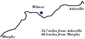
Motoring through the Mountains - 1930s: Wilmot
Jackson County
Altitude: 1,880 feet
The community of Wilmot was mentioned in the Federal Writer’s Project’s book, North Carolina: A Guide to the Old North State (Chapel Hill: University of North Carolina Press, 1939). The guide commented that, “At the end of a little valley just past WILMOT, . . . (1,865 alt., 250 pop.), is the only view of the Smokies from this route east of Bryson City. Clingmans Dome (R) is barely distinguishable from the other peaks.”
 |
||
Return to the Map for the 1930s
Sources & Readings
- Federal Writers’ Project of the Federal Works Agency, Works Projects Administration. North Carolina: A Guide to the Old North State. Chapel Hill: University of North Carolina Press, 1939.
- Jackson County Genealogical Society. Jackson County Heritage, North Carolina, 1992. Cullowhee, NC: JCGS, 1992 (Volume 1) and 2000 (Volume 2).
- Williams, Max R., ed. The History of Jackson County. Sesquicentennial ed. Sylva, NC: Jackson County Historical Association, 2001.