Travel Western North Carolina
Taking the Train: Topton
Cherokee County
Altitude: 2,700 feet
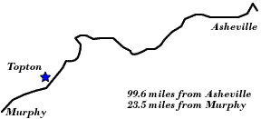
"Commandingly situated almost at the crest of a ridge of the Balsam Mountains, Topton is a favorite resort for hunters and fishermen. It is interesting to note, concerning this station, that Robbinsville, the county seat of Graham County, is served from it with mail twice a day. Robbinsville, although an important community, has no railroad facilities, and no railroad approaches nearer to it than at Topton, from which it is twelve miles distant. Within a few hundred feet of Topton station the Railway crosses the line between Cherokee and Macon Counties, and after traversing the extreme Northwest corner of the latter county, passes into Swain County, 96.8 miles from Asheville and 26.3 miles from Murphy. A mile further along is Nantahala, N.C."
TRAIN STALLED IN TUNNEL
"Over 100 Passengers Cooped Up All Night on the Murphy Branch – Numerous Washouts On Account of Cloudburst. Special to The Observer.
"Asheville, July 12. – A special this afternoon from Andrews, on the Murphy branch says: Heavy rain, practically a cloud-burst, last night caused numerous washouts, flooding the track over two feet for half a mile, near Topton. A number of trestle supports were carried away, paralyzing traffic. Train No. 19 stalled in a tunnel five miles east of Andrews. Over a hundred were on board all night. The trestle at the east entrance of the tunnel gave way on the passing of the rear coach, and ditching was narrowly avoided. The train was brought to a stop in the tunnel. Investigation ahead revealed another washed-out bridge 50 feet from the west end of the tunnel. The train is still unable to proceed either way. The coaches were packed with people, two in a seat, some standing all night. Many women and children attending the Topton barbecue were aboard. A majority of the passengers walked to Andrews over the flooded tracks for breakfast. The wires are crippled.”
- Charlotte Observer, July 13, 1905
| To the West: Andrews |  |
To the East: Nantahala |
Return to the Southern Railway Map for the 1910s
Text excerpted from 1912 travel guide, The Western North Carolina Section at a Glance. Issued by the Passenger Traffic Department, Southern Railway, Premier Carrier of the South, Washington, D.C., 1912.
Sources & Readings
- Cherokee County Historical Museum. A Pictorial History of Cherokee County. Murphy, N.C.: Cherokee County Historical Museum, 1995.
- Freel, Margaret Walker. Our Heritage, The People of Cherokee County, North Carolina, 1540 – 1955. Asheville, N.C.: Miller Print. Co., 1956 [c1957].
- White, Alice, D., ed., and White, Nell A., associate ed. The Heritage of Cherokee County, North Carolina. Winston-Salem, N.C.: Cherokee County Historical Museum in cooperation with the History Division of Hunter Pub. Co., 1987.
- Williams, Michael Ann, essay, inventory, and photography; Dockery, Carl, ed. Marble & Log: The History & Architecture of Cherokee County, North Carolina. Murphy, N.C.: Cherokee County Historical Museum Council, Division of Archives and History, North Carolina Department of Cultural Resources, 1984