Travel Western North Carolina
Taking the Train: Andrews
Cherokee County
Altitude: 1,800 feet
Population: 936
"This charming town lies nearly in the center of a valley approximately nine miles long, known as the Vale of Konnahecta. This was the Cherokee name for the Valley River, very near which Andrews is situated. Lumbering and tanning are the chief industries of Andrews, and, as it is the trading center of a large and prosperous section considerable business is done here. From the postoffice here residents of the country as far east as Aquone on the Nantahala River, in Macon County, are served daily with mail over a rural route. The scenery in the surrounding country is inspiring. To the north of the town Toanna Bald rises majestically to a height of 4,708 feet, and to the South Weatherman’s Bald towers to a height of more than 4,600 feet. Within easy driving distance is Mt. Tuni, the highest of the Pusquitta Balds, which rears into the clouds 5,291 feet. Outside of the valley in which Andrews is located the surrounding country is wild and rugged and sublimely beautiful."
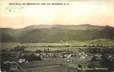
Supported by several industries and drawing upon the resources of a rich agricultural area, the town of Andrews incorporated in 1904 and supported a population of about 1,000 by 1910. This view of the Band Mill of Graham County Lumber Company is dated August 1916. As in other communities, rail connection made industrial development possible which otherwise could not be supported by existing roads. In his report on Forest Conditions in Western North Carolina (1911), J.S. Holmes noted that the roads in Cherokee County were “rough,” even though “several miles of road running out of Andrews have been macadamized . . . .”
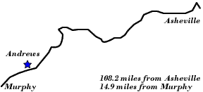
"From this point the altitude of the Railway increases rapidly, the rise being nine hundred feet within a distance of nine miles. Swinging across the Valley River again, a short distance from Andrews, the Railway two miles and a half from the bridge plunges directly under a mountain through the Valley River Tunnel, 104.1 miles from Asheville and 19 miles from Murphy. The tunnel is 346 feet long and is a remarkable piece of railroad engineering . One mile beyond the tunnel is Rhodo, a small way station, noteworthy in no special particular. The next station is Topton, N.C."
In its February 19, 1915, issue, the Jackson County Journal (Sylva, N.C.) ran an article quoted from the Andrews, N.C., newspaper, The Andrews Sun, entitled “New Enterprise at Andrews.”
“The Graham County Lumber Co., Col. Frank Buell, president, has purchased about 30 acres of land, adjoining the property of the North Carolina Tanning Extract Co., and will erect thereon a large wood working plant, which will use over ten million feet of lumber annually, mostly low grade chestnut oak and other hardwoods.
“In this immense plant which will be equipped with up-to-date machinery, the lumber will be kiln dried, and then cut up into table tops and other furniture demension [sic] stock, also made into house trim, and a specialty will be made of “cores,” that is the small pieces will be glued together and made ready to be veneered onto later by furniture manufacturers.
“All the chestnut shavings trips and saw dust will be saved and the tannic acid extracted later, so that nothing will be wasted.“The entire machinery will be driven by electric motors, driven from large generators operated by steam made from the waste from the wood working machines.
“A large number of men will be employed and this big pay roll will be a welcome addition to Andrews diversified industries.”
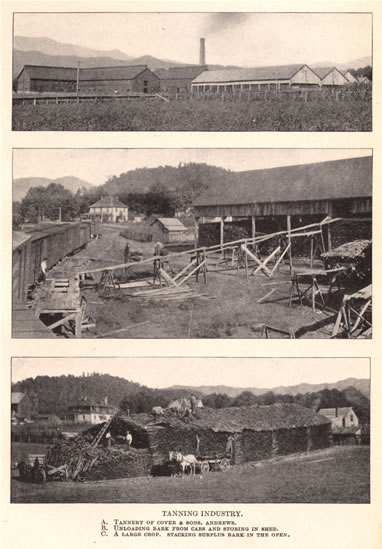
The travel guide The Western North Carolina Section at a Glance (1912), quoted above, noted that “lumbering and tanning are the chief industries of Andrews.” This point was illustrated in a three-part picture from J.S. Holmes’ Forest Conditions in Western North Carolina (1911) entitled “Tanning Industry,” and which featured (A) “Tannery of Cover & Sons, Andrews,” (B) “Unloading bark from cars and storing in shed,” and (C) “A large crop. Stacking surplus bark in the open.”
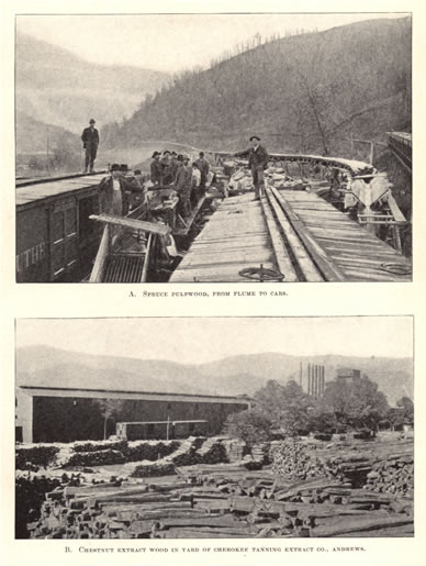
Holmes’ Forest Conditions in Western North Carolina (1911) also contained a two-part image of “Pulpwood and Tanning Extract Industries,” which showed (A) “Spruce pulpwood, from flume to cars,” and (B) “Chestnut extract wood in yard of Cherokee Tanning Extract Co., Andrews.” The first image, “Spruce pulpwood,” is not specifically credited as being in Andrews.
Finally, Holmes commented on the importance of the tanning industry to western North Carolina:
“Five large tanneries, at Andrews, Sylva, Hazelwood, Asheville, and Rosman, are in operation west of the Blue Ridge. Their combined annual output of bark amounts to about 24,000 cords, which comes mainly from this region, and takes practically the entire output. Only a few thousand cords, chiefly from the easternmost counties, go to outside tanneries.”
| To the West: Regal |  |
To the East: Topton |
Return to the Southern Railway Map for the 1910s
Text excerpted from 1912 travel guide, The Western North Carolina Section at a Glance. Issued by the Passenger Traffic Department, Southern Railway, Premier Carrier of the South, Washington, D.C., 1912.
Sources & Readings
- Cherokee County Historical Museum. A Pictorial History of Cherokee County. Murphy, N.C.: Cherokee County Historical Museum, 1995.
- Freel, Margaret Walker. Our Heritage, The People of Cherokee County, North Carolina, 1540 – 1955. Asheville, N.C.: Miller Print. Co., 1956 [c1957].
- Holmes, J.S. (John Simcox). Forest Conditions in Western North Carolina. In cooperation with the Forest Service, United States department of Agriculture, Henry S. Graves, forester. Raleigh: Edwards and Broughton Printing Company, 1911.
- White, Alice, D., ed., and White, Nell A., associate ed. The Heritage of Cherokee County, North Carolina. Winston-Salem, N.C.: Cherokee County Historical Museum in cooperation with the History Division of Hunter Pub. Co., 1987.
- Williams, Michael Ann, essay, inventory, and photography; Dockery, Carl, ed. Marble & Log: The History & Architecture of Cherokee County, North Carolina. Murphy, N.C.: Cherokee County Historical Museum Council, Division of Archives and History, North Carolina Department of Cultural Resources, 1984.